Pucon, Chile
January 10, 2005
Ruta 40 – Part 2
At Perito Moreno Glacier,
Los Glaciares NP, Argentina
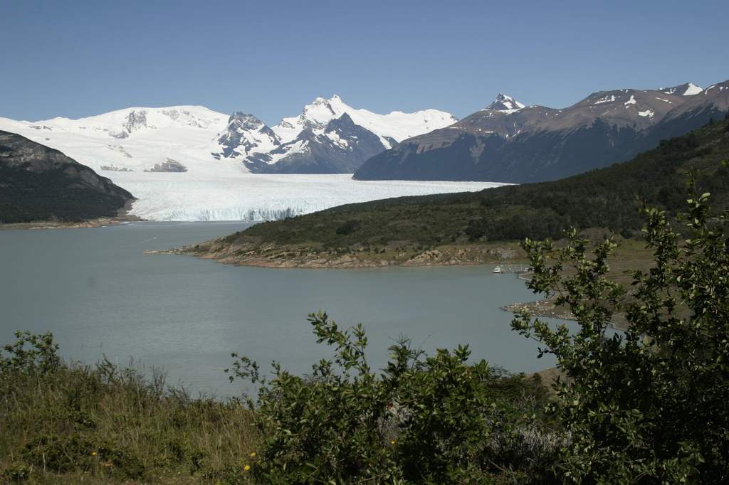 In the foreground are small trees that resemble a huckleberry, but with a
smaller leaf, and grow to a height of 10 –15’ (3 – 4m). They soften the glare of
brilliant sunshine reflecting from solid ice.
In the foreground are small trees that resemble a huckleberry, but with a
smaller leaf, and grow to a height of 10 –15’ (3 – 4m). They soften the glare of
brilliant sunshine reflecting from solid ice.
Just beyond the trees and far below, lies an expense of rock, 500’ (150m) across
perhaps, and scoured clean by the advance and retreat of the glacier over the
years. It must have covered them recently because no vegetation presently grows
there. And beyond the rocks the face of the glacier rises to the advertised
height of nearly 200’ (60+m), although a middle section appears much higher. A
small section where the glacier has carried gravel with it is a dirty gray;
almost black in spots. The rest of the face is so purely white, although with a
distinctly blue tint to it caused by eons of pressure, that when I remove my
polarized glasses, I can’t view it for some time.
Every few minutes a crack like a rifle shot shatters the silence, and tons of
ice falls to the rocks and water below.
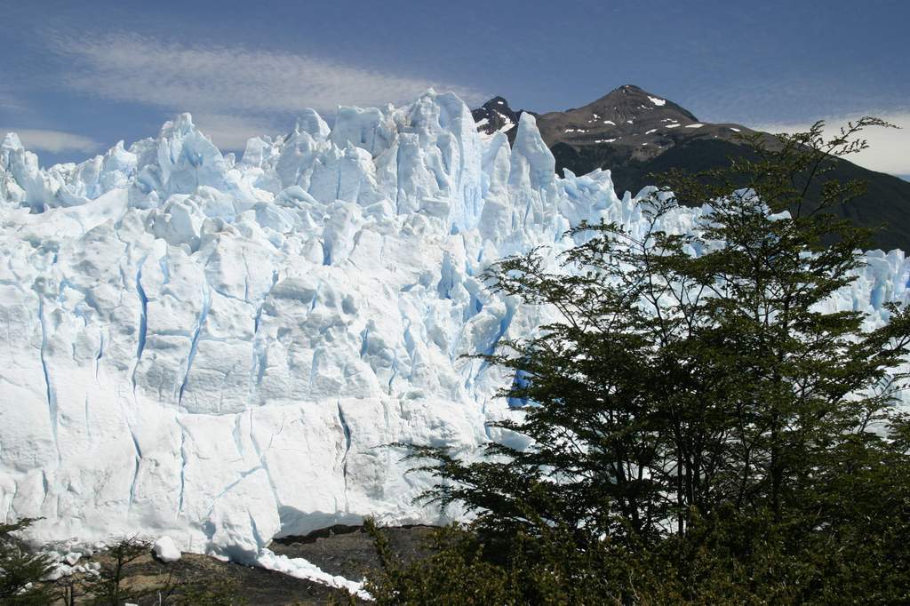
Huge fractures define the face of this immense wall of ice. From my vantage
point, perhaps 1,000’ (300m) away, they appear no wider that half the width of
my fist extended at arm’s length, but knowing the height of the wall, surely
each section is as large as a house. Some blocks are pinnacles soaring to the
sky; the size of a 20-story office building. Others appear as the spires of an
exquisite cathedral.
 Overlooking this jumble of ice, rocky peaks with vegetation to half their height
pierce the blue sky. Close to the summits, bowls hold snow deposits, substantial
in their own right, but that pale in comparison to the immense and spectacular
wall of ice in the foreground. In the furthest views, the glacier climbs like an
elevator to the stars, its movement imperceptibly slow, far up the flanks of the
very highest peaks; peaks that could be 5 or 20 miles (8 – 30km) away. It’s hard
to tell. Cirrus clouds occasionally fill an otherwise clear blue sky.
Overlooking this jumble of ice, rocky peaks with vegetation to half their height
pierce the blue sky. Close to the summits, bowls hold snow deposits, substantial
in their own right, but that pale in comparison to the immense and spectacular
wall of ice in the foreground. In the furthest views, the glacier climbs like an
elevator to the stars, its movement imperceptibly slow, far up the flanks of the
very highest peaks; peaks that could be 5 or 20 miles (8 – 30km) away. It’s hard
to tell. Cirrus clouds occasionally fill an otherwise clear blue sky.
It was 75F degrees in the parking lot, but the temperature has easily fallen 15F
- 20F degrees as I approached the viewing area. Tourists of all ages speak a
dozen tongues. Colorful backpacks are ubiquitous, as is the camera equipment
from Kodak, Nikon and Canon. We’ve all come to partake of nature’s visual feast
that is Perito Moreno.
While in Puerto Natales, I determined from my map that the 280 miles (500km)
north from Torres del Paines N.P. to Perito Moreno Glacier will mostly be
gravel, but as I’ve mentioned previously, the roads in South America are being
rapidly upgraded, and all but a 100 miles turn out to be paved. What a treat.
Even the wind cooperates for a change as it is relatively calm for at least half
the distance, with the blowing not starting in earnest until mid-afternoon. I
camp near Perito Moreno Glacier, then spend a night in El Calafate before
continuing my ride north up Ruta 40 and on to the Carretera Austral.
North up Ruta 40
It’s 460 miles (750km) from El Calafate (the town closest to Los Glaciares N.P.)
north on Ruta 40 to the Chilean border at Los Antiguos, then roughly another 400
miles (700km) north up the Carretera Austral. [Note: I previously called this
road in Chile the Camino Austral, because that’s the name that Lonely Planet
uses. However, locally, the term Carretera is used. I’ll use that term as well.)
From the discussions that I’ve had with other travelers, virtually all of this
is gravel.
 The distances are much too far and the conditions too unpredictable, for me to
approach this in anything but sections, and the first piece is to the Chilean
border at Los Antiguos. I buy a 10-liter gas container in El Calafate, because
it’s said that there’s no gas in the 240-miles (400km) between Tres Lagos and
the settlement of Bajo Caracoles. Under normal circumstances I could just make
that 240 miles (400km) (six gallons x 40mpg) but I’ve been averaging around
37mpg in the wind. It’s Tuesday morning when I head north, not to Bajo
Caracoles, which I think is a stretch for a one-day ride on gravel, but to Las
Horquetas about 50 miles (80km) closer. On my map by Las Horquetas is marked
Hotel cerrado, and I hope to spend the night there, although interestingly
enough, Chris and Erin stayed fairly close by, and didn’t mention the hotel.
The distances are much too far and the conditions too unpredictable, for me to
approach this in anything but sections, and the first piece is to the Chilean
border at Los Antiguos. I buy a 10-liter gas container in El Calafate, because
it’s said that there’s no gas in the 240-miles (400km) between Tres Lagos and
the settlement of Bajo Caracoles. Under normal circumstances I could just make
that 240 miles (400km) (six gallons x 40mpg) but I’ve been averaging around
37mpg in the wind. It’s Tuesday morning when I head north, not to Bajo
Caracoles, which I think is a stretch for a one-day ride on gravel, but to Las
Horquetas about 50 miles (80km) closer. On my map by Las Horquetas is marked
Hotel cerrado, and I hope to spend the night there, although interestingly
enough, Chris and Erin stayed fairly close by, and didn’t mention the hotel.
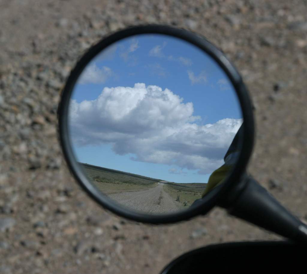
When the pavement ends at the intersection of Ruta 40, less than 20 miles (30km)
east of El Calafate, I drop the pressure in both tires and point the Beemer
toward Tres Lagos and gas, another 80 miles (130km) further north. The road
winds around the east end of Lago Argentino and parallels Rio La Leona, before
enjoying views into glaciers at the west end of Lago Viedma. The wind picks up.
This is the only road from Los Glaciares N.P. to the town of El Chalten, and Mt.
Fitz Roy, a major tourist destination nearby, so even though the surface is
rough, it’s well traveled. Buses and 4x4 “overland tour vehicles” mix it up with
the odd rental car. At least a half dozen vehicles per hour pass by;
freeway-level traffic on these roads.
There is precious little out here except some nice rock formations, an
infrequent sign pointing down a dirt road to an estancia many miles away, or the
occasional building abandoned as a hotel or restaurant. The latter are surely
someone’s dream, which fell victim to low traffic counts. It seems all so
inevitable. But by 2:30pm I’ve covered the 100 miles (160km) to Tres Lagos, and
have taken the time to both gas up and eat lunch. I’ve also remembered to fill
my extra 10-liter tank. I should be able to ride the 150 miles (250km) to Hotel
cerrado by 7pm, and at about 250 miles (400km) total, that will make a nice day
of riding on gravel. I press on.
I’m counting on Hotel cerrado because there are very few places to stay out
here. Eric and Gail Haws (my friends from Oregon, introduced earlier) stayed at
an estancia named La Siberia (just the very name conjures up a warm fire and
comfy bed!) on an earlier trip, but at only 80 miles (130km) north of Tres
Lagos, it’s a bit soon for me and I continue on. The road changes from packed
dirt, to washboard and back. I adjust my speed to reflect the current
conditions. The wind howls. I’ve heard that camping may be possible another 40
miles (70km) further on at Estancia La Verde (The Green Ranch, but the Spanish
is so much more poetic), but I’m making good time on the rough road and not only
am I shooting for Las Horquetas, but I’m starting to think that I can make the
additional 55 miles (90km) to Bajo Caracoles. Besides, a nice hotel room seems
like more my style tonight. To mitigate the danger of the 20-pound fuel bomb
that I’ve strapped to the back of the bike, I empty the 10 liters into my gas
tank in two separate stops.
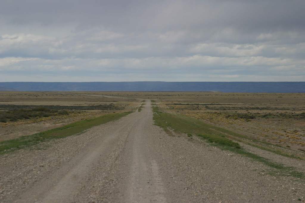
North of La Siberia Ruta 40 traverses a particularly flat and desolate part of
western Patagonia. The foothills are far away and the land is featureless.
Rarely is there a view west to the snow-covered peaks of the Andes. This
landscape defines forsaken.
 Chris and Erin pitched their tent in an abandoned building at Casa Tamel Aike, a
town marked on the map. I had been warned that not much was there, and I can
confirm that a house is all that exits. A man waives as I pass by. A few head of
cattle graze on a nearby hillside. Chris and Erin’s abandoned building still
stands across the road. If it was later in the day and I was more tired, it
surely would work as an emergency campsite. At least you would be out of the
wind. But gosh, what an awful place.
Chris and Erin pitched their tent in an abandoned building at Casa Tamel Aike, a
town marked on the map. I had been warned that not much was there, and I can
confirm that a house is all that exits. A man waives as I pass by. A few head of
cattle graze on a nearby hillside. Chris and Erin’s abandoned building still
stands across the road. If it was later in the day and I was more tired, it
surely would work as an emergency campsite. At least you would be out of the
wind. But gosh, what an awful place.
For the past few dozen miles, the road has changed back and forth from packed
dirt on which I can sometimes exceed 50mph to the worst washboard with
grapefruit-sized stones, on which 10mph is barely possible. By now my mind is
set on Bajo Caracoles. The hotel, my original destination, is less than 10 miles
(15km) away, and it’s not yet 6pm. An Africa Twin rider that I met earlier in
the trip made it from El Calafate to Bajo Caracoles in one day. I’m starting to
believe that I can do likewise.
It’s almost 6:30pm when I arrive at Las Horquetas, and find nothing but an
intersection that points me to Estancia La Oriental and Perito Mereno N.P., both
over 50 miles away, to the west. I’m surprised by the absence of the hotel but
maps are sometimes wrong, and of course, things change. I’m clearly shooting for
Bajo Caracoles now, which I’ve been told has gas and a restaurant, although
there’s been no mention of lodging. I’ve decided that I’ll pitch my tent any
place that I can find that’s out of the wind.
Cloud cover has settled in, and it’s gotten cold, even though the sun won’t set
for at least three hours. I’m wearing five layers on top, and three on the
bottom. My handlebar heaters are set to full on. The wind is howling, and with
the sun hiding, it’s a lethal combination. Although I’m in no danger, it is
quite uncomfortable. By focusing on just the next ten miles, I count down the
distance. When I check my odometer, perhaps two miles have passed. A few minutes
later, perhaps two or three more. Usually I check the odometer four or five
times before ten miles (15km) passes. At 60 miles (90km) I focus on getting to
50 (80km). At 40 miles (70km) I focus on getting to 30 (50). The road continues
north, one rock and pothole at a time.
Of course I make Bajo Caracoles. I’m in by about 8:30. It takes ten hours to
ride the 320 miles (500km) north from El Calafate. It turns out that there are
two places (I just can’t bring myself to describe them as anything that might
pass for a hotel) that provide lodging, but both are full. I camp, but at least
I get out of the wind. Dinner with a Brazilian radiologist is the high point of
my day. He is in the middle of a 25-day tour of Patagonia with a colleague, two
4x4 Land Cruises and two drivers. He attended a year of high school in the
United States as an AFS participant.
I don’t remember undressing when I crawled into the tent at
10pm, but the next morning I’m in my sleeping bag. I guess I did. Who would
know?
North of Bajo Caracoles
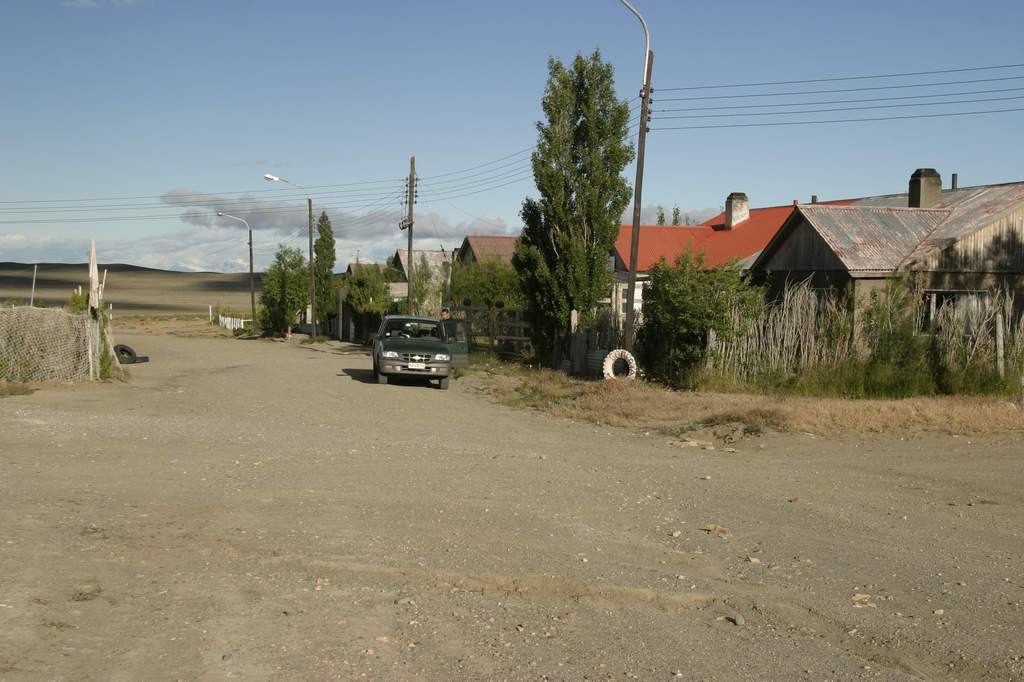 When I leave Bajo Caracoles on Wednesday morning, the road is actually worse
than it was on Tuesday. The saving grace is that it’s also a much shorter trip.
It takes me 4 ½ hours to complete the 80 miles (130km) to the town of Perito
Moreno, although that includes stopping on the roadside and talking to a Swiss
motorcyclist for 20 minutes. He is headed south from Alaska to Ushuaia on his
Honda Transalp, after leaving Alaska in August. That all sounds vaguely
familiar. He’s surprised when I mention that I’m an American, and says that I’m
the only American motorcyclist that he’s met during his travels through Latin
America.
When I leave Bajo Caracoles on Wednesday morning, the road is actually worse
than it was on Tuesday. The saving grace is that it’s also a much shorter trip.
It takes me 4 ½ hours to complete the 80 miles (130km) to the town of Perito
Moreno, although that includes stopping on the roadside and talking to a Swiss
motorcyclist for 20 minutes. He is headed south from Alaska to Ushuaia on his
Honda Transalp, after leaving Alaska in August. That all sounds vaguely
familiar. He’s surprised when I mention that I’m an American, and says that I’m
the only American motorcyclist that he’s met during his travels through Latin
America.
I catch another break. The road west to Los Antiguos on the Chilean border is
paved. I clear customs, catch the ferry across Lago Buenos Aires with minutes to
spare, ride in the snow for a few minutes over the high Andes pass just west of
Puerto Ibanez and arrive in Coyhaique, Chile by 8pm. It’s the following day when
it finally occurs to me that cerrado is the Spanish word for closed. No wonder
Hotel cerrado wasn’t capitalized on my map.