Nazca, Peru
August 30, 2004
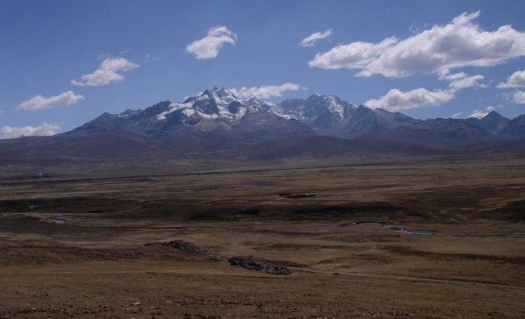
Cordillera Blanca and Huaraz
 Three
nights in a 3-star hotel (Hotel Andino) in Huaraz is just the medicine I need
after the rigors of the road to Caraz. In my $15 hostals I’ve made do with
showers lacking pressure and tepid water. At Hotel Andino (not $15) the water is
hot, plentiful and under steady and appropriate pressure. The Swiss-run
management took me in filthy and tired; they put me back on the street clean and
with renewed confidence.
Three
nights in a 3-star hotel (Hotel Andino) in Huaraz is just the medicine I need
after the rigors of the road to Caraz. In my $15 hostals I’ve made do with
showers lacking pressure and tepid water. At Hotel Andino (not $15) the water is
hot, plentiful and under steady and appropriate pressure. The Swiss-run
management took me in filthy and tired; they put me back on the street clean and
with renewed confidence.
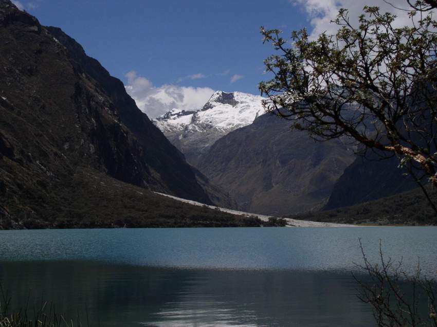
In one quick day I change from traveler to tourist and join a bus trip to Lago
de Llanganuco, a jewel of a mountain lake at 3,800m (12,000’); surrounded by
6,000m peaks. The bus ride up the steep mountain road is the type that generates
the infrequent news in the US, about Peru. “Tourist bus rolls into ravine and
kills 40.” We survived intact. The daylong trip ended at the cemetery at Yungay.
On May 31, 1970, 18,000 villagers were buried in a massive landslide and mudflow
as a 7.7 earthquake shook the nearby Cordillera Blanca. That natural disaster,
the worst ever recorded in the Western Hemisphere, killed 70,000 people in
central Peru.
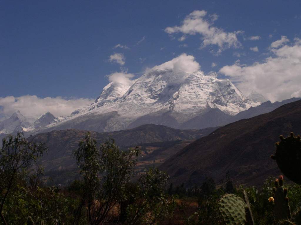
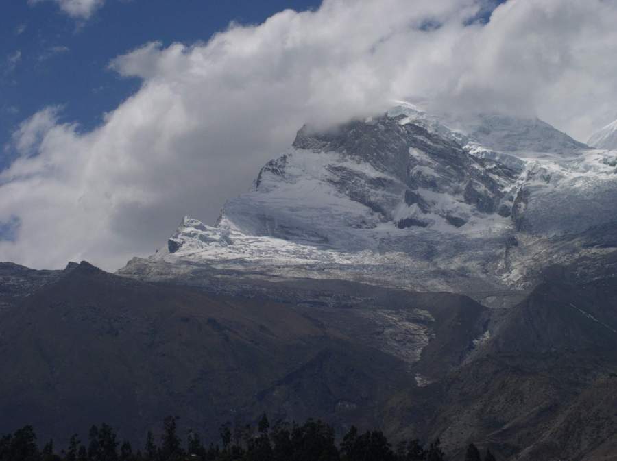
Even with my Thesaurus I have run out of words to describe the magnificent
Cordillera Blanca. I’ll let my pictures do the talking.
Huaraz to Nazca
 From
Huaraz, already at 10,000’, the road back to the Panamericana Norte (as the Pan
American Highway is properly called north of Lima) crosses an ever-broadening
valley between the Cordillera Blanca and the Cordillera Negra, and continues
it’s gradual ascent to a pass south of the village of Pachacho, marked on my map
as 4,080m (13,341’.) It’s a beautiful and lonely ride for the first hour as
grasslands roll away to the nearby mountains. I see an occasional sheepherder
tending his flock and two llamas graze by the roadside. As I pass through small
villages that appear to just cling to survival in what must surely be an
inhospitable environment, children, in full uniform, play in their schoolyards.
From
Huaraz, already at 10,000’, the road back to the Panamericana Norte (as the Pan
American Highway is properly called north of Lima) crosses an ever-broadening
valley between the Cordillera Blanca and the Cordillera Negra, and continues
it’s gradual ascent to a pass south of the village of Pachacho, marked on my map
as 4,080m (13,341’.) It’s a beautiful and lonely ride for the first hour as
grasslands roll away to the nearby mountains. I see an occasional sheepherder
tending his flock and two llamas graze by the roadside. As I pass through small
villages that appear to just cling to survival in what must surely be an
inhospitable environment, children, in full uniform, play in their schoolyards.
 At
this high elevation, even in the late morning, I stop to pull on a warm trekking
jacket and then flip on my handlebar warmers (one of the most important
accessories on a touring motorcycle, I think.) Helge Pederson (a Norwegian now
living in Seattle and author of a book which explains his own motorcycle journey
– 10 Years on Two Wheels) was once quoted as saying that the most important
thing on a touring motorcycle was a heated seat. I’m with you Helge, and I could
use one now!
At
this high elevation, even in the late morning, I stop to pull on a warm trekking
jacket and then flip on my handlebar warmers (one of the most important
accessories on a touring motorcycle, I think.) Helge Pederson (a Norwegian now
living in Seattle and author of a book which explains his own motorcycle journey
– 10 Years on Two Wheels) was once quoted as saying that the most important
thing on a touring motorcycle was a heated seat. I’m with you Helge, and I could
use one now!
But as I crest the pass, the road simply falls out from under me and I descend
13,000’ to sea level at Paramonga in seventy-five miles. At times switchbacks
are stacked a dozen deep on this dizzying drop. The road surface, however, is
excellent; and with the great handling characteristics of this BMW, I hardly
break stride. In a little over an hour I’m watching workers cut sugar cane just
a few miles from the coast, as I shed my jacket and kill the hand warmers. I hit
the Pan-Americana Norte (north) and head south toward Lima.
 For
well over a thousand miles (and extending another thousand miles or more deep
into neighboring Chile) coastal Peru is sand dunes and more sand dunes,
interspersed with the occasional oasis that supports large-scale agriculture as
rivers run from the Andes to the Pacific Ocean. Corn and sugar appear to be the
main crops, but vegetables of every type are evident. An oasis might last for a
mile or ten, but then the land changes again to desert, where there isn’t enough
water to support even a blade of grass.
For
well over a thousand miles (and extending another thousand miles or more deep
into neighboring Chile) coastal Peru is sand dunes and more sand dunes,
interspersed with the occasional oasis that supports large-scale agriculture as
rivers run from the Andes to the Pacific Ocean. Corn and sugar appear to be the
main crops, but vegetables of every type are evident. An oasis might last for a
mile or ten, but then the land changes again to desert, where there isn’t enough
water to support even a blade of grass.
This is not sightseeing country, rather land that just needs to be crossed, and
I keep my speed up. Seventy-five miles north of Lima the Panamerican Norte turns
into a full-fledged four-lane superhighway with a 90kph (54mph) speed limit. As
an aside, this road is so good that in Germany there would be no limit, and I
want to go faster to put the dunes behind me. However, I’ve been warned several
times that the Peruvian National Police love to write tickets on this road, and
I engage my Caterpillar cruise control (a small, yellow Cat o-ring that squeezes
between the throttle and handlebar) and cool my heels at about 55mph. In fifth
gear I’m barely pulling 3,500rpm. But the miles pass quickly as there are
neither villages nor speed bumps – just miles of dunes and open roads.
I’ve also been warned repeatedly about Lima and crime against vehicles on the
Panamericana. It is reputedly so bad, that in a call on Thursday night to my
friend Ivan in Lima, he offers to meet me north of Lima and escort me through
Lima on surface streets. Twice I try to call him from an hour north of the city,
but without success. It’s almost 3pm and decision time. I can keep trying and
maybe end up staying in Ancon, or with three hours of daylight left, push ahead.
I decide to move on.
The suburbs are bad; they clearly look dangerous. On a bike I’m obviously very
exposed. I’ve heard and read several stories of carjacking and robbery. While
the Panamericana continues in four lanes and the traffic keeps moving, I’m fine.
However, at one point we’re diverted onto city streets due to construction. With
the traffic stopped, young men walk among the cars selling everything from CDs
to water. I’m concerned, and decide to stop at the first hostal I see, if
concern turns to real fear. But forty-five minutes later the Panamericana Norte
turns into the Panamericana Sur (south) and I’m on my way to Chincha Alto where
I spend the night. I’ve done 369 miles – my longest day so far.